Post provided by Francesco Carotenuto
A very important ecological feature of a species is its geographic range, which can be described by its size, position and shape. Studying the geographic range can be useful to understand the ecological needs of a species and, thereby, to plan conservation strategies. In ecological studies, mathematical models are the new standard to reconstruct the distribution of living species on Earth because of their accuracy in predicting a species presence or absence at unsampled locations. These methods are able to reconstruct the climatic niche of a species and to project it onto a geographic domain in order to predict the species’ spatial distribution. To do this, besides the occurrences of a species, the models necessarily require the spatial maps of environmental variables, like temperature and precipitation, for all the study area.
Is it possible to apply these highly performant methods to fossil species to reconstruct how and where they distributed in the past? Many emulators of past climate are now available and they are extensively used to model spatial distribution of fossil species and their environmental needs when they were alive. Although these past climates are provided at very fine spatial and temporal resolutions, they are not available for the remote past like 10, 100 or even 300 million years ago. Traditionally, deep time fossils geographic ranges were reconstructed by using geometric tools like the Minimum Convex Polygon (MCP), Alpha-hull, latitudinal range and great circle distance. All these tools are perfectly suited for providing range size estimations for comparative and evolutionary studies but, unfortunately, they have low accuracy in reconstructing a species’ presence or absence at unsampled locations. So, how to use the predictive power of model-based methods to reconstruct the spatial distribution of deep time fossil species?

The answer is in the community ecology. In a mature living community, a species must balance its environmental preferences with those of the other neighbour species. Once this equilibrium has become stable, the spatial distribution of a species is determined by its climatic needs and by the ecological relationships with the neighbouring species. Past communities worked in the same way. In the deep past, for which no climatic reconstructions are available, in most cases we can observe only one component determining the spatial distribution of a fossil species: its relationships with the other species in the same fossil record. So why are we not using this “ecological component” to reconstruct the geographic range of fossil species?

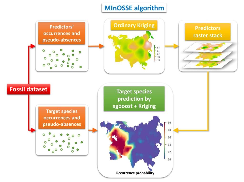
Here comes MInOSSE (Massively Interpolated Occurrences for Species Spatial Estimation), a model-based method that simply uses the spatial distribution of many fossil species, that lived at the same time in a territory, as “ecological” variables to be used to reconstruct the geographic range of just one target species. First, MInOSSE reconstructs the spatial distribution of each fossil species by means of spatial interpolation and, then, it uses these new ecological variables in a Machine Learning Algorithm to predict the geographic range of a target species. In practice, MInOSSE uses these ecological variables in the same way other mathematical models use climatic variables to reconstruct the ecological niche of a species and, then, to reconstruct the species’ geographic range.
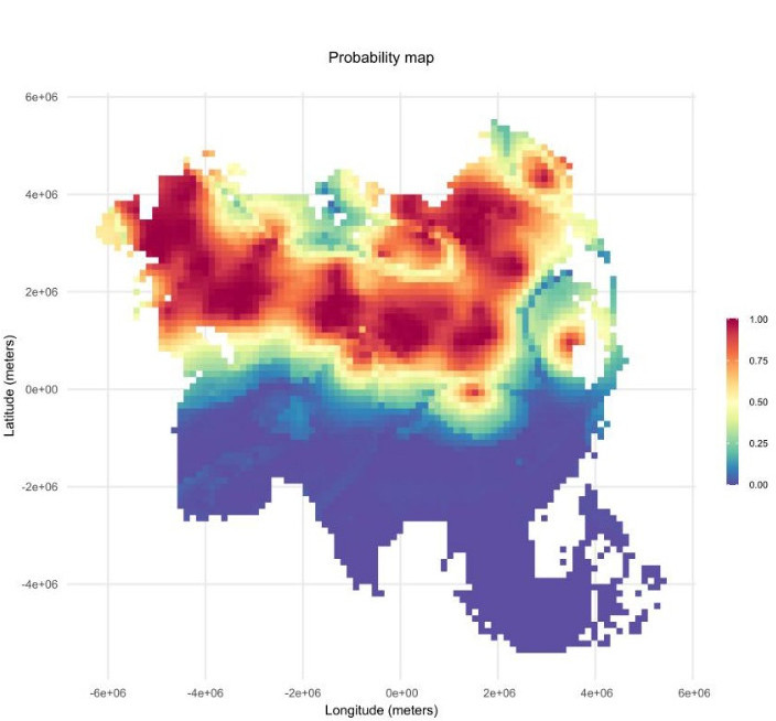
Simulations proved that MInOSSE greatly outperformed the traditional geometric tools in reconstructing the spatial distribution of virtual fossil species. MInOSSE performance was also tested with some living and extinct control species and the method’s predictions were surprisingly accurate. One of the most striking evidence of the MInOSSE power is the geographic range reconstruction made for the recently extinct woolly mammoth. This prediction highly resembles other reconstructions made by using model-based methods with past climate variables as predictors and coincides with the known distribution of the “mammoth steppe”, the past biome over which the mammoth roamed during the Ice Age. This method proved to be a new valid tool for macroecological studies.
To carry out its task, MInOSSE only needs a dataset of fossil species occurrences provided with geographical or paleo-geographical coordinates and mean age estimations of the fossil sites. The level of precision of the paleontological information is crucial for the method to predict the most accurate geographic distribution of deep time species.

MInOSSE is available for the R software environment with a GPL license. It is the first outcome of the EcoPast project and it comes along with other functions allowing to compute deep time species geographic ranges projected over past world maps. Instructions for the installation and a first run can be found in the wiki page.
To read more about the MInOSSE method and its uses for geographical range estimation, check out the Methods in Ecology and Evolution article, ‘MInOSSE: A new method to reconstruct geographic ranges of fossil species’
