
Post provided by Torcuato Pulido Mantas
I am a postdoctoral researcher in Marine Biology and Ecology at the Department of Life and Environmental Sciences (DiSVA), Polytechnic University of Marche, where I work in the Zoology Lab (link: https://www.instagram.com/zoomardisva/). We focus on understanding how climate change affects benthic marine organisms, developing new methods for marine environmental monitoring, and promoting effective conservation strategies for vulnerable habitats and species.
The idea behind this new perspective on monitoring marine animal forests emerged during my PhD, while reviewing photogrammetry-based surveys across terrestrial and marine ecosystems. Screening more than 2,000 studies exposed me to emerging three-dimensional approaches for mapping complex habitats. I noticed that point clouds generated through Structure-from-Motion (SfM) photogrammetry underwater were strikingly similar to those produced by LiDAR in terrestrial forestry. This observation raised a simple question: why were forestry inventory methods not being applied to their marine counterparts?
Forests have long been recognized as three-dimensional ecosystems. Their vertical structure—canopies, understory, gaps—controls biodiversity, energy flow, and ecosystem services. Over the past century, forest science has progressively moved from local, manual inventories to automated, landscape-scale monitoring, driven by airborne LiDAR, photogrammetry, and increasingly sophisticated point-cloud analytics.
In the ocean, an analogous transition is just beginning. Marine animal forests (MAFs) are benthic ecosystems dominated by long-lived, sessile filter and suspension feeders such as sponges, gorgonians, bryozoans, and ascidians. When dense, these organisms form complex three-dimensional canopies that increase habitat heterogeneity, alter near-bottom hydrodynamics, and provide shelter and nursery grounds for numerous species. Despite their ecological importance, most MAFs—especially those outside coral reefs—remain poorly monitored, largely because three-dimensional assessments underwater are difficult and costly.

Borrowing concepts from terrestrial forestry
In terrestrial ecosystems, canopy structure is routinely quantified using automated workflows developed for forest inventory. These methods detect individual trees, estimate their height, and quantify canopy volume from LiDAR-derived point clouds. The key idea behind our work was to test whether similar pipelines could be transferred to marine systems using SfM-photogrammetry instead of LiDAR.
SfM now allows the reconstruction of dense three-dimensional point clouds of benthic habitats from underwater imagery. These datasets are increasingly common, yet their analysis often remains manual or two-dimensional. We adapted a standard forestry workflow to underwater point clouds, aiming to establish a semi-automated framework for characterizing canopy-forming organisms (CFOs) and their collective canopy. The central idea of our study is straightforward: rather than inventing entirely new tools for the marine realm, why not test whether established forestry pipelines can be adapted to underwater three-dimensional data?
A LiDAR-inspired workflow for the seafloor
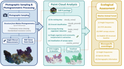
The proposed pipeline includes five steps:
- denoising the point cloud to remove reconstruction artifacts;
- classifying ground points, separating substrate from biological structures;
- normalizing heights relative to the substrate, correcting for substrate irregularity;
- detecting individual CFOs, using local maxima detection analogous to single-tree segmentation.
- quantifying canopy volume and canopy occupancy, by means of voxelizing process.
All steps were implemented using open-source tools, including the lidR R package originally developed for forest science. To evaluate performance, semi-automated outputs were compared against manual annotations of CFO abundance, density, and height manually derived directly from the point clouds.
Performance and limitations
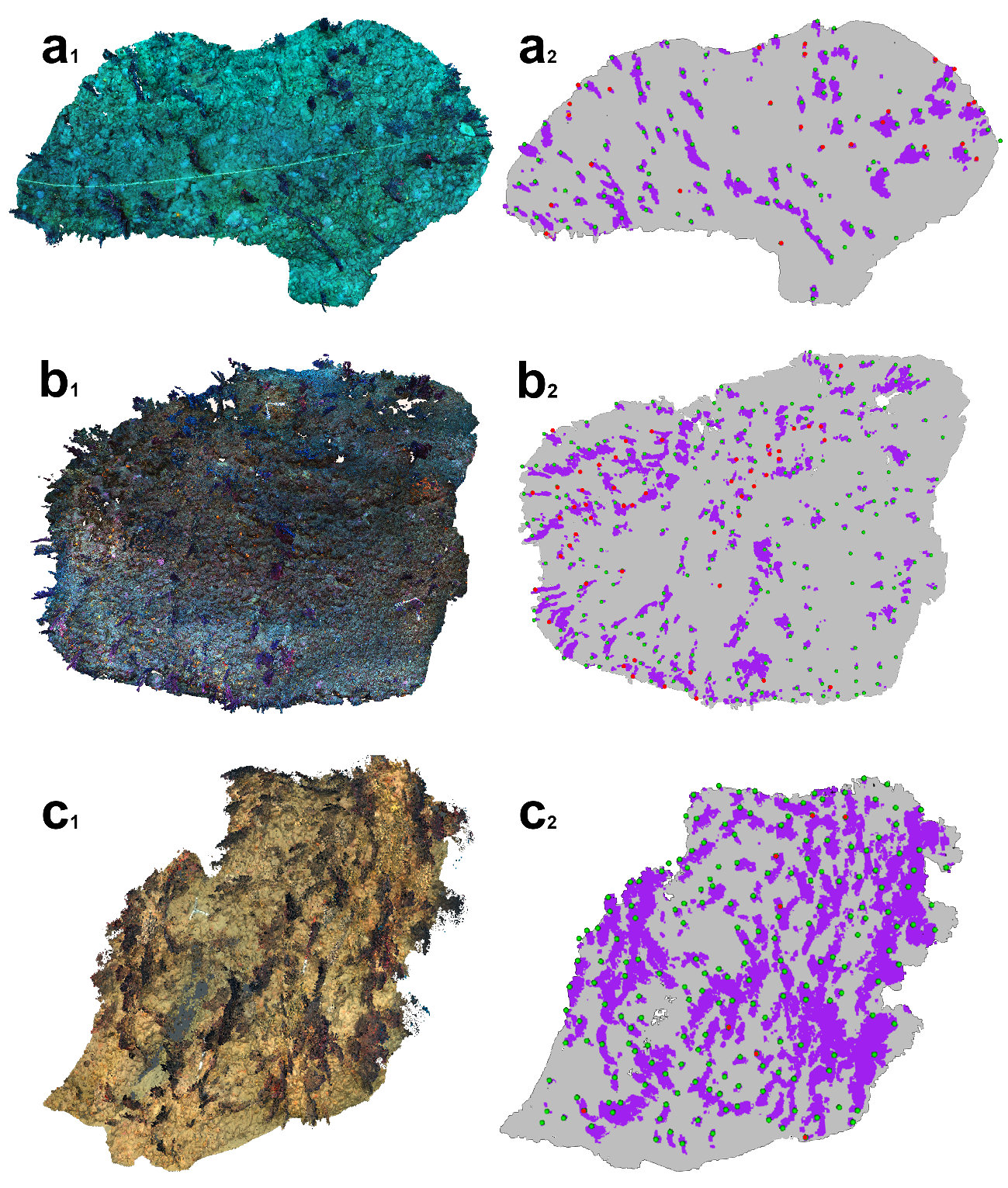
CFO detection performed well, with an average F1-score of 0.77, comparable to tree detection accuracy in terrestrial forests. Most errors resulted from fixed search-window parameters, leading to occasional over- or under-segmentation—issues already well known in forestry and solvable through adaptive parameterization.
Height estimation was more challenging. Accuracy varied among sites, with systematic overestimation in areas with steep or irregular substrates. Errors in ground classification and height normalization propagated into CFO height estimates, especially on vertical surfaces and complex rocky outcrops. Additionally, unlike plants, sessile invertebrates do not follow gravitropic or phototropic growth patterns, which further complicates height metrics. These results highlight that morphology and topography strongly influence performance and that no single parameterization fits all MAF types.
Why are canopy volume and occupancy the real advance?
While height estimation requires refinement, the key innovation probably lies in the quantification of canopy volume. Animal forest canopies represent a 3D interface between the seafloor and the water column, influencing flow, biogeochemical processes, and habitat complexity. Canopy volume provides a direct proxy for habitat capacity and ecosystem integrity, moving beyond traditional two-dimensional metrics such as cover or density. Moreover, historically, soft-bodied canopy formers have been excluded from structural assessments due to methodological constraints. This framework enables standardized, semi-automated three-dimensional quantification for the first time, opening new opportunities for integrating ecological, hydrodynamic, and biogeochemical perspectives.

A first step toward operational 3D marine monitoring
By transferring forest inventory methods to the seafloor, it shifts the focus from species counts to canopy structure and functional habitat metrics. In doing so, it opens new possibilities for scalable surveys, cross-ecosystem comparisons, and more ecologically meaningful indicators—essential ingredients for the effective conservation and management of these vulnerable underwater forests.
Read the full article here.
