Our Associate Editor Ryan Chisholm of the National University of Singapore tells us about the recent Practical Tools article he handled for MEE which presents a method for estimating canopy fuel load from hemispherical photographs.

Fire is a natural process in many ecosystems, but large-scale intense fires can threaten biodiversity, as well as human life and property. Although the annual global area burnt has decreased slightly in recent decades, modelling suggests it is likely to increase in the future, particularly in boreal forests, due to a warming climate and drying fuel (Wu et al. 2021). This is of concern because boreal forests are a major store of carbon, and their burning can itself contribute to climate change, leading to further warming and further burning—a positive feedback with dire global consequences.
In the boreal forests of northern Canada, forest managers are faced with the more immediate concern of predicting fire risk, based on field measurements and modelling. A key input to such models is the quantity of combustible material in the forest canopy, known as canopy fuel load. Until now, assessment of canopy fuel load has required laborious and costly field measurements.
In this blog post, we explain how a novel method presented in a recent Practical Tools article by Cameron et al. (2021) facilitates fast and accurate assessment of canopy fuel loads in a boreal forest with just a smartphone, fisheye lens attachment, and freely available software.
Old and new methods for canopy fuel assessment
Traditional methods for assessing canopy fuel loads rely on time-consuming manual measurements of tree diameters and heights, which are then plugged into specialised equations. More-recent alternative methods involving hemispherical photography have been developed, but until now these have been subject to several limitations: estimates of canopy fuel load can be sensitive to light conditions and camera exposure, and cameras must be carefully levelled, e.g., with tripods. Thus photographers must be specially trained to follow detailed protocols and can operate only under suitable environmental conditions.
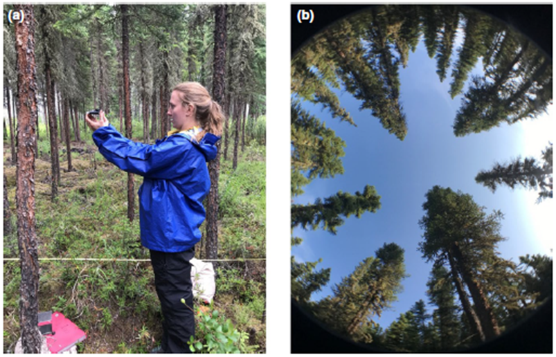
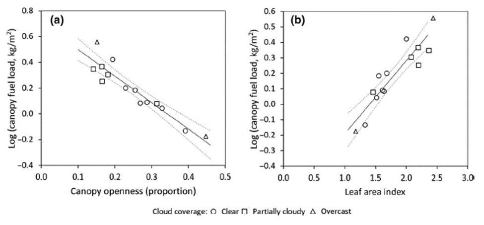
The novel method of Cameron et al. gets around many of these difficulties. They attach a fisheye lens to a smartphone and process the hemispherical images taken using recently published free software (the R package caiman; (Díaz 2021)) . Their method can be easily deployed by forest managers or fire crews, as it does not require specialised training or protocols: there is no need for meticulous levelling techniques, and different photographers can be used across sites. Their resulting estimates of canopy openness explain over 80% of the variation in canopy fuel load measured with traditional methods.
Applicability
The new method can in principle be deployed immediately to help staff on the ground estimate fire risk in the Canadian boreal forests where the study was carried out. This is important, given the region’s role on the global carbon cycle. Future work should focus on adapting the method to and testing its accuracy in other forests around the world.
To find out more, read the full article by Cameron et al. here. You can also see more of our Practical Tools articles here.
