
Post provided by Christine Beardsworth
Tracking the movement of animals is important for informing conservation practices but can present logistical obstacles, especially when attempting to track smaller species with large GPS tags. Using existing technologies in new ways may help overcome these obstacles and provide alternative approaches for accurately tracking large numbers of relatively small sized species. In this blog post, Christine Beardsworth discusses findings from her recent Methods in Ecology and Evolution paper “Validating ATLAS: a regional-scale, high-throughput tracking system”.
Tracking animals
Tracking where animals go, and when, is key to understanding how they influence and how they are influenced by the environment. With this information, we can make predictions that aid in conservation efforts and help scientists to understand fundamental aspects of animal life.
Nowadays, there are many tracking systems available. Take GPS as an example. The same technology that helps people get from A to B in a car can also be used to track where animals go. However, lightweight GPS devices for small animals can be very expensive, which means that few animals can be monitored unless a project is very well funded. Often, tracking devices also need to be retrieved from the animal to download the data, which can be problematic if a species is not easily recaptured. There is not yet one perfect system for all species, but technology is always advancing and great strides have been made in using radio transmitters to locate animals remotely.
Radio tracking is not new. Scientists have been manually tracking animals with handheld antennas for decades, and estimated locations of animals through triangulation. Radio transmitters are cheap, lightweight and long-lasting (even with transmissions every few seconds), however, finding each animal can take a long time and may only yield one or two locations per day, per individual.

Attempts have been made to automate this practice, and ATLAS is one such system. ATLAS uses an array of receiver stations – each with their own antenna – to detect the time of arrival of transmissions from custom Ultra High Frequency radio transmitters. These transmitters (or tags, as they are often referred to) can be less than a gram in weight, but the total weight of the tag is largely dependent on the size of battery used.
A new regional scale system: ATLAS
Since being developed over the last decade by Ran Nathan (Hebrew University of Jerusalem) and Sivan Toledo (Tel-Aviv University), along with colleagues at the Minerva Center for Movement Ecology, the use of ATLAS systems has expanded. There are currently 6 ATLAS systems operational worldwide and over 50 species have been tagged and tracked using an array of ATLAS receivers. In our paper, we use the largest of these systems – the Wadden Sea ATLAS system (or WATLAS, as we like to call it) – to categorise the accuracy and precision of ATLAS.
The Wadden Sea is an ideal location for this testing as it is an intertidal zone with little radio interference in the vicinity. The mudflats – on which some of the receivers are built – offer a large area with no interruptions to the horizon, like buildings or trees, that may block radio signals, therefore the “line-of-sight” between transmitters and receivers is limited mainly by the curvature of the earth.

We tested the system using a combination of ‘stationary’ and ‘moving’ tests, where the lead author, Christine, took an ATLAS tag and a GPS unit with her across the mudflats on pre-determined routes to specific locations within the array. By comparing the ATLAS and GPS locations, we could get an idea of the accuracy of the system. We found little difference (<10m) between the ATLAS and GPS estimates of location, demonstrating that the system was quite reliable. We also used data that had been collected on tagged red knots to ascertain how well the system worked for small shorebirds.
Shorebirds in the Wadden Sea
Apart from the technical aspects that make WATLAS an excellent model system, the Wadden Sea itself is a UNESCO world heritage site and a highly important ecosystem that is home to millions of shorebirds. Many of these shorebirds overwinter here or stage during much longer global migrations. Our focus has so far been on tracking red knots, a migratory shorebird species that breeds in the arctic. There are several sub-species of red knot, including the canutus subspecies, which stops in the Wadden Sea briefly, on its way to Western Africa for the winter, and the islandica sub-species – which we study – that stays in the Wadden Sea during the winter.
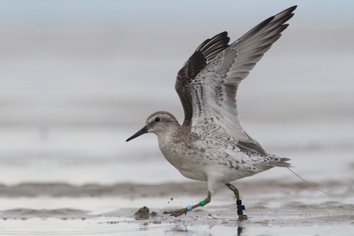
We focus our research around the island of Griend, and found that ATLAS was able to track red knots while they were on the mudflat. We also found that we tracked red knots in flight, with paths across the whole western Wadden Sea where the nearest receiver stations were more than 15 km away. This means that the system can be highly effective, even for small animals. This is good news for co-author Evy Gobbens, who will use ATLAS during her PhD to monitor the movement of five shorebird species, including the very small (~50 g) dunlin. ATLAS will aid in her assessment for how these species may be affected by sea level rise in the future.
Lead author bio
Christine Beardsworth is a post-doctoral researcher at the NIOZ (Royal Netherlands Institute for Sea Research). She works with Allert Bijleveld to investigate the movement ecology of red knots in the Wadden Sea and has a keen interest in the individual-level factors that influence behaviour.
You can read the full paper ‘Validating ATLAS: a regional-scale, high-throughput tracking system’.

One thought on “ATLAS: a regional-scale tracking system”