
Our March issue is now online now! This issue contains 23 articles about the latest methods in ecology and evolution, including a special feature on Methods in Ecological forecasting, fossils citizen science and much more! Read to find out about this month’s featured articles and the article behind our cover.

Ecological niche modelling (ENM), species distribution modelling and related spatial analytical methods were first developed in two-dimensional (2-D) terrestrial systems. The use of 3-D environmental data generates more precise estimates of environmental conditions for training ENMs. This method also improves inference of species’ suitable abiotic ecological niches and potential geographic ranges. Here the authors present the voluModel R package and provide a simple modelling workflow for Luminous Hake, Steindachneria argentea, as an example.
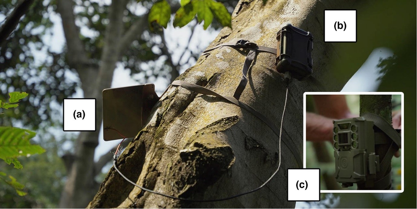
Efforts to preserve, protect and restore ecosystems are hindered by long delays between data collection and analysis. Threats to ecosystems can go undetected for years or decades as a result. Real-time data can help solve this issue but significant technical barriers exist. Using an off-the-shelf camera trap (Bushnell™) and customised existing open-source hardware to create a ‘smart’ camera trap system. Images captured by the camera trap are instantly labelled by an artificial intelligence model and an ‘alert’ containing the image label and other metadata is then delivered to the end-user within minutes over the Iridium satellite network. New artificial intelligence models such as this will expand the system’s potential for other, real-time use cases including real-time biodiversity monitoring, wild resource management and detecting illegal human activities in protected areas.

Accurate measurements of soil respiration (Rs) are critical for understanding how soil carbon will respond to environmental changes. However, a commonly used method for Rs measurements, the collar deployment method, may introduce artefacts that cause bias in Rs measurements. The objective of this article was to quantify the effect of long-term collar deployment on Rs and to unravel potential causes due to changes in the soil environment. Findings suggested that such potential artefacts should be considered when interpreting Rs data based on long-term collar deployment.
Hemispherical photography (HP) is a long-standing tool for forest canopy characterization. Currently, there are low-cost fisheye lenses to convert smartphones into highly portable HP equipment (smartphone-based HP, hereafter SHP). However, there is an obstacle to having a close-to-ideal method for citizen science and large-scale or opportunistic sampling: the known sensitivity of HP to illumination conditions. The purpose of this article is to test a ready-to-use approach based on previous research and to contribute to quantifying the errors associated with choosing SHP in non-recommended light conditions over well-established HP practices.

The weather station on the cover

This month’s cover image shows an unmanned weather station on the Anysberg Mountain in South Africa’s Cape Floristic Region. Weather data from such stations can be combined with other environmental observations such as population surveys or satellite remote sensing to create ecological forecasts to help address conservation challenges and provide insights into the dynamics of ecosystems. In this issue, Slingsby, et. al. use the Cape Floristic Region, a global biodiversity hotspot, as a case study to promote the development of regionally focused ecological forecasting systems. Developing shared data pipelines that drive multiple forecast models helps reduce logistical challenges in under-resourced regions, while comparison or coupling of models across scales facilitates new fundamental insights. Developing data pipelines that deliver up-to date information to decision-makers are valuable even before highly accurate forecasts are available. Photo credit: ©Adam M. Wilson.

One thought on “Our March issue is out now!”