This year’s UN Climate Change Conference (COP26) will be held in Glasgow in November, and now more than ever before, the pressure is on for world leaders to agree on climate action to keep global warming below 1.5°c. In the lead up to the conference, we’re asking our editors and authors to share their research at the interface of climate and ecology.In this post, Jesus Aguirre Gutierrez of the University of Oxford presents research on the role of functional diversity in the response of tropical forests to climate change.
The demands of a growing human population are putting increasing pressure on the Earth’s natural systems and services. Dubbed the ‘Anthropocene’, we are currently living in a period where human actions are directly altering many earth processes, including atmospheric, geologic, hydrologic and biospheric processes. Climatic change and the resulting consequences, including rising temperatures, changing precipitation (i.e. rainfall, snow etc) and increase in frequency of storm events, represent the biggest challenge to our future and the life-support ecosystems that make our world habitable.
Artist’s interpretation of global climate change. Photo credit: Pete Linforth/Pixabay.
In 1970, Earth Day was launched as a modern environmental movement and a unified response to an environment in crisis. Earth Day has provided a platform for action, resulting in the creation of the Environmental Protection Agency (EPA), The Clean Air, Clean Water and Endangered Species Acts in the US and more globally. This year, 22 April marks the 50th anniversary of Earth Day, and the number one environmental crisis theme which needs immediate attention is ‘Climate Action’. Many of our ecosystems on earth are degrading at an alarming pace and we are currently experiencing a species loss at a rate of tens or hundreds of times faster than in the past.
“Man must rise above Earth to the top of the atmosphere and beyond, for only then will he fully understand the world in which he lives” – Socrates (469-399 BC)
Since the launch of the first Landsat mission in 1972, several new earth observation satellites made their way into Earth’s orbit. As of 2018, UNOOSA recorded an impressive 1980 active satellites. Of those, 661 were dedicated to earth observation. These numbers show how widespread the use of remote sensing technologies has become.
The annual BES Macroecology Special Interest Group conference took place on the 10th and 11th of July. This year the meeting was in St Andrews, Scotland. Over 100 delegates came together in this old University town to discuss the latest research and concepts in macroecology and macroevolution.
Remote Sensing, Funky Koalas and a Science Ceilidh
The conference opened with a plenary by Journal of Applied Ecology Senior Editor Nathalie Pettorelli from ZSL. She talked about how remote sensing can be used in ecological and conservation studies. In the other plenary talks, we heard from:
Anne Magurran from the University of St Andrews discussing turnover and biodiversity change
Brian McGill from the University of Maine talking about the data-driven approach to the “biodiversity orthodoxy” and challenging the conventional wisdom about macroecological change
We also hosted a student plenary speaker, Alex Skeels, who gave a lively talk about diversification and geographical modelling using some pretty funky disco koalas. In addition to these talks, there were 60 short 5 minutes talks and 20 posters. Continue reading “BES Macroecology 2018: Macroecology and Data”
Each year an uncountable number of airborne organisms, mainly birds and insects, venture out on long journeys across the globe. In particular, the mass movements of birds have fascinated humankind for hundreds of years and inspired a wealth of increasingly sophisticated studies. The development and improvement of individual tracking devices in animal research and has provided amazing insights into such extensive journeys. Study of mass movements of biological organisms is still a challenge on continent-wide or cross-continental scales.
One tool that can effectively track and/or monitor large numbers of birds is radar technology. Radars offer many advantages over other methods such as visual counts or ringing. They’re less expensive, need less effort, offer better visibility and detectability, and are more applicable for large-scale monitoring. Networks of meteorological radars (as opposed to individual radars) seem particularly promising for large-scale studies. Continue reading “Radar Wind Profilers: A Widespread but Unused Remote Sensing Tool for Migration Ornithologists”
In an age of rapid technological advances, ecologists need to keep abreast of how we can improve or reinvent the way we do things. Remote sensing technology and image analysis have been developing rapidly and have the potential to revolutionise how we count and estimate animal populations.
Using remotely sensed imagery isn’t new in ecology, but recent innovations mean we can use it for more things. Land use change and vegetation mapping are among the areas of ecology where remote sensing has been used extensively for some time. Estimating animal populations with remotely sensed imagery was also demonstrated more than 40 years ago by detecting indirect signs of an animal with some success: think wombat burrows and penguin poop.
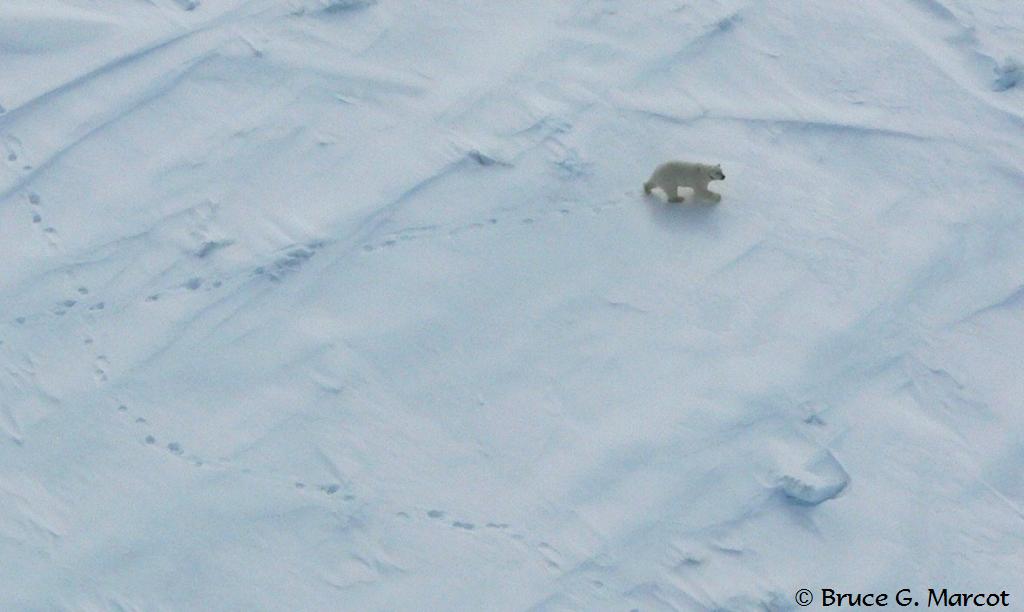
A polar bear from a helicopter
Thanks to improved spatial and spectral resolution (see the text box at the bottom of the post for a definition), accessibility, cost and coverage of remotely sensed data, and software development we have now reached a point where we can detect and count individual animals in imagery. Many of the first studies to demonstrate automated and semi-automated techniques have taken computer algorithms from other disciplines, such as engineering or biomedical sciences, and applied them to automate counting of animals in remotely sensed imagery. It turns out that detecting submarines is not so different to detecting whales! And finding abnormal cells in medical imaging is surprisingly similar to locating polar bears in the arctic! Continue reading “Remote Sensing for Counting Animals: Polar Bears, Sheep and Everything In-Between”
Animal biologging is a technique that’s quickly becoming popular in many cross-disciplinary fields. The main aim of the method is to record aspects of an animal’s behaviour and movement, alongside the bio-physical conditions they encounter, by attaching miniaturised devices to it. In marine ecosystems, the information from these devices can be used not only to learn how we can protect animals, many of whom are particularly vulnerable to disturbance (e.g. large fish, marine mammals, seabirds and turtles), but also more about the environments they inhabit.
Challenges when Tracking Marine Animals
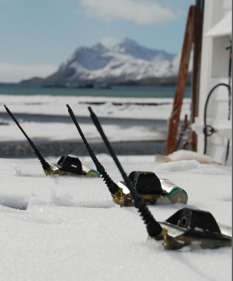
Many marine animals have incredibly large ranges, travelling 1000s of kilometres. A huge advantage of biologging technologies is the ability to track an individual remotely throughout its range. For animals that dive, information on sub-surface behaviour can be obtained too. This information can then be retrieved when an animal returns to a set location. If this isn’t possible (e.g. individuals that make trips that are too long or die at sea), carefully constructed summaries can be relayed via satellite. This option provides information in real time, which can be very useful for researchers.
Tracks of juvenile southern elephant seals. Red tracks are individuals that returned to their natal colony. Grey are those individuals whose information would have been lost had it not been transmitted via the Argos satellite system.
This new Special Feature is a collection of five articles (plus an Editorial from Guest Editors Bill Sutherland, Lynn Dicks, Mark Everard and Davide Geneletti) brings together authors from a range of disciplines (including ecology, human geography, political science, land economy and management) to examine a set of qualitative techniques used in conservation research. They highlight a worrying extent of poor justification and inadequate reporting of qualitative methods in the conservation literature.
As stated by the Guest Editors in their Editorial “these articles constitute a useful resource to facilitate selection and use of some common qualitative methods in conservation science. They provide a guide for inter-disciplinary researchers to gauge the suitability of each technique to their research questions, and serve as a series of checklists for journal editors and reviewers to determine appropriate reporting.”
New method faster, more efficient and less damaging to the environment
A team of researchers from the University of Wollongong (UOW) and the University of Tasmania has developed a new method for assessing the health of fragile Antarctic vegetation using drones, which they say could be used to improve the efficiency of ecological monitoring in other environments as well.
The researchers have written about their method in an article published in Methods in Ecology and Evolution, a scientific journal of the British Ecological Society.
Movement ecology is a cross-disciplinary field. Its main aim is to quantitatively describe and understand how movement relates to individual and population-level processes for resource acquisition and, ultimately, survival. Today the study of movement ecology hinges on two 21st century advances:
Animal-borne devices/tags (biologging science, Hooker et al., 2007) and/or remote sensing technology to quantify movement and collect data from remote or otherwise challenging environments
Computational power sufficient to manipulate, process and analyse substantial volumes of data
Although datasets often involve small numbers of individuals, each individual can have thousands – sometimes even millions – of data points associated with it. Study species have tended to be large birds and mammals, due to the ease of tag attachment. However, the trend for miniaturisation of tags and the development of remote detection technologies (such as radar, e.g. Capaldi et al., 2000), have allowed researchers to track and study ever smaller animals. Continue reading “Movement Ecology: Stepping into the Mainstream”