Our July issue is now online now! This issue contains 19 articles about the latest methods in ecology and evolution, including a special feature on active remote sensing, seed morphology, drones and much more! Read to find out about this month’s featured articles and the article behind our cover

Special feature
Active sources of remote sensing data, in particular Light Detection and Ranging (LiDAR) and Radio Detection and Ranging (RADAR), majorly differ from passive sources by offering data of three-dimensional (3D) character, which help representing the earth terrain, surface and the related structural attributes. Therefore, active remote sensing and the methods developed for its data analysis can support ecosystem inventory and analysis. This cross-journal special feature hosts a series of innovative publications from multiple disciplines, but with a common focus on the state-of-the-art science and applications of active remote sensing for ecology, biodiversity and conservation.
Featured articles

Remote sensing (RS) and geospatial sciences already amount to a long history of fostering research in topics related to ecology. Data and methods have mainly been subject to research and experiments, but trends are now emerging that suggest the use of RS in practical applications like nationwide monitoring programs and assisting global conservation goals. The studies in this Special Feature and trends shown by other recent works at the interface of ecology and active RS confirm the ongoing shift from indirect and solely proxy-based approaches to direct and more data-science driven methods in approaching ecology and conservation problems by means of active sensors.
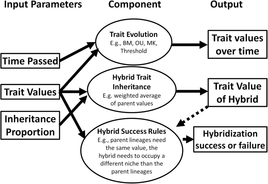
Gene flow is increasingly recognized as an important macroevolutionary process. The many mechanisms that contribute to gene flow (e.g. introgression, hybridization, lateral gene transfer) uniquely affect the diversification of dynamics of species, making it important to be able to account for these idiosyncrasies when constructing phylogenetic models. This article presents SiPhyNetwork, an R package for simulating phylogenetic networks under a birth–death-hybridization process.
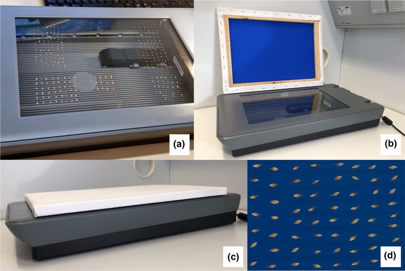
The description of biological objects, such as seeds, mainly relies on manual measurements of few characteristics, and on visual classification of structures, both of which can be subjective, error prone and time-consuming. This article provides a simple image acquisition and processing protocol and introduces Traitor, an open-source software available as a command-line interface (CLI), which automates the extraction of seed morphological traits from images.
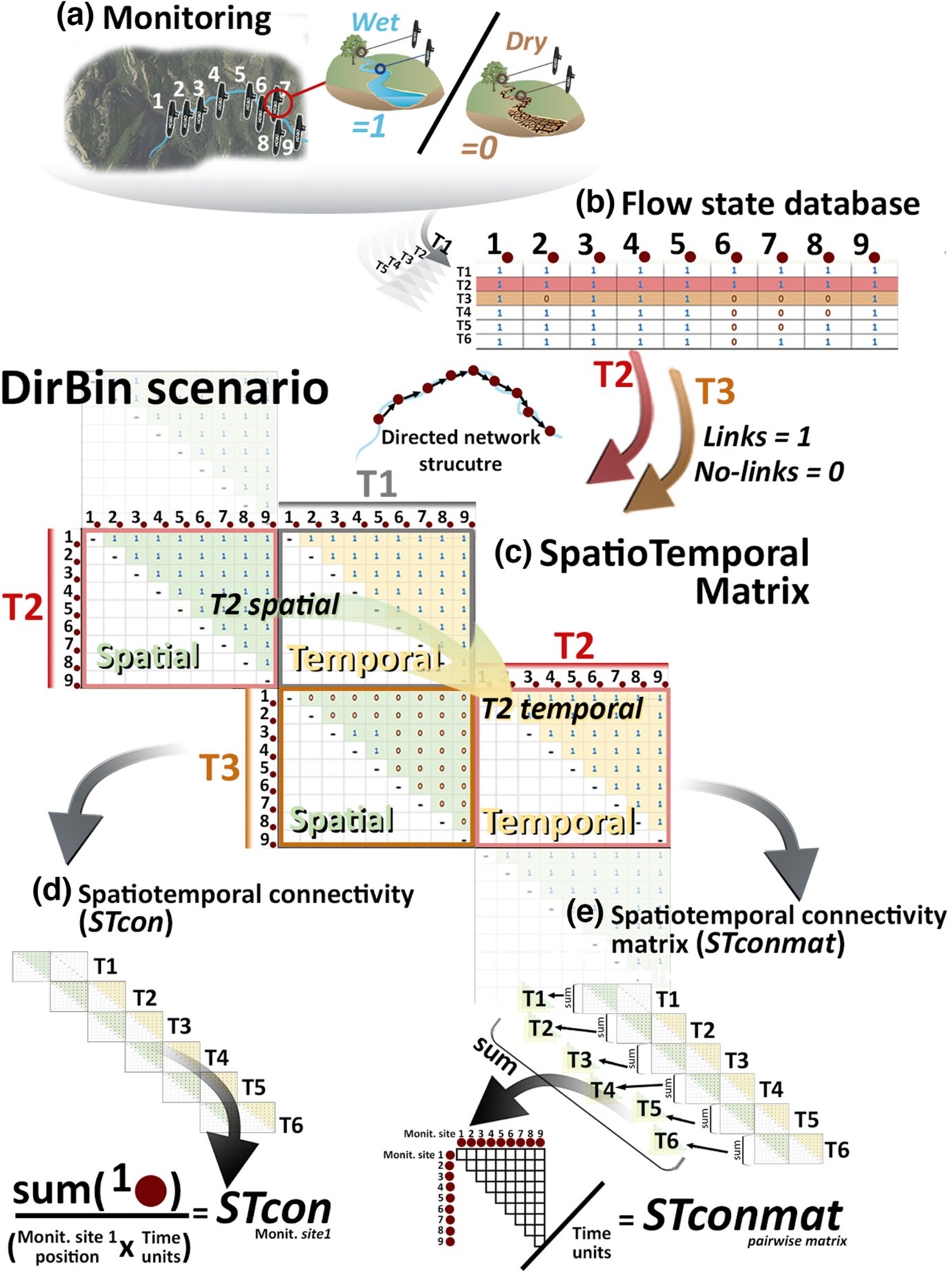
The growing interest in combining spatial and temporal patterns in nature has been fostered by the current availability of high-frequency measurements. However, we still lack a methodological framework to process and interpret spatiotemporal datasets into meaningful values, adaptable to different time windows and/or responding to different spatial structures. The authors of this article developed and tested a framework to evaluate spatiotemporal connectivity using two new measures: the spatiotemporal connectivity (STcon) and the spatiotemporal connectivity matrix (STconmat).

Locally observed biodiversity always consists of only a fraction of its site-specific species pool. Why some suitable species are absent, shaping dark diversity of that site, is a basic yet increasingly crucial question in the face of global biodiversity degradation. This article proposes a metric, dark diversity affinity (DDA), which measures the tendencies of individual species to be absent from suitable sites and of individual sites to miss suitable species. This framework provides a concept and methodological toolbox that allows identification of the processes underlying dark diversity and advances both the theory of community ecology and biodiversity conservation.
The drone on the cover
This month’s cover photo looks out over the savanna landscape of Mpala Research Centre, Kenya, as an unoccupied aerial vehicle (UAV) collects lidar (light detection and ranging) remote sensing data. Recent advancements in autonomous flight and remote sensing technologies have made high-resolution, 3-D surveys of vegetation structure with UAV-lidar more accessible than ever. Flight and sensor parameters, such as altitude, speed, and lidar pulse rate, can all be easily tweaked to fit the exact purpose of a vegetation or topographic survey. Boucher et al.’s article explores how UAV flight and sensor parameters can be optimized for surveying the tree-grass mosaic of savanna ecosystems, which are much less well-studied than forest vegetation structure. The study evaluates how flight and sensor settings impact lidar data at a typical savanna site in Kruger National Park, South Africa, using the Harvard Animal Landscape Observatory (HALO), a sensor package designed for UAVs. With detailed data comparisons and a lot of fancy flying, they show how flying high or low, fast or slow, and with full or low power impacts a set of lidar vegetation structure metrics. © Peter Brehm Boucher.
