Post provided by VANESSA ADAMS

©Amy Kimber (NERP Northern Australia Hub)
Invasive weeds cause environmental and economic harm around the world. Land managers bear a heavy responsibility for the control of infestations in what is often a time-consuming and costly battle.
Fortunately, an increasing number of research-based solutions are giving land managers an advantage. This includes tools to determine the distribution of weeds and also the development of modelling approaches to predict their spread.
Understanding the current and future distribution of an invasive species allows managers to better direct their limited resources. However, the direct and strategic management of weeds is tricky and that’s why population models (in particular spatial dispersal models that can be applied without much data) are needed to inform and facilitate action on the ground.
Moving beyond Suitability: Understanding Demography and Spread of Invasive Species
The two main approaches to modelling the distribution and spread of invasive species are:
- Habitat suitability approaches, in which species distribution models predict areas of possible occupancy based on habitat characteristics.
- Population dynamic models based on demographic processes and/or landscape structure that model spread and outcomes of invasion. These approaches rely on spatial distribution data of invasive species, environmental predictors, and basic population data.
While habitat suitability approaches are useful for managing risk at regional scale, managers need local scale information about where to expect new infestations. This is where population dynamic models can be used to model the spread of weeds and predict areas at highest risk of invasion. But these models are typically data hungry and more often than not we have a limited understanding of the biology of emerging invasive species. This means managers must often make a tough decision: act now with limited knowledge or wait to learn more and risk escalating costs of control, reduced economic returns and decreased feasibility of management.

We set out to develop a model to help fill those knowledge-gaps. Our spatially explicit, individual-based spread model can be applied in data-poor situations to model future spread of invasive plants and help inform management strategies. The model was built for managers and policy makers in northern Australia working on species where expert knowledge and environmental data are often lacking, but is flexible and easily adapted for other scenarios. The model predicts the probability of occurrence over a user-specified, typically short-term time frame. The result can be used to direct surveillance and management actions to areas that have the highest likelihood of rapid invasion and spread.
Real World Examples of how Spread Models can Inform Management

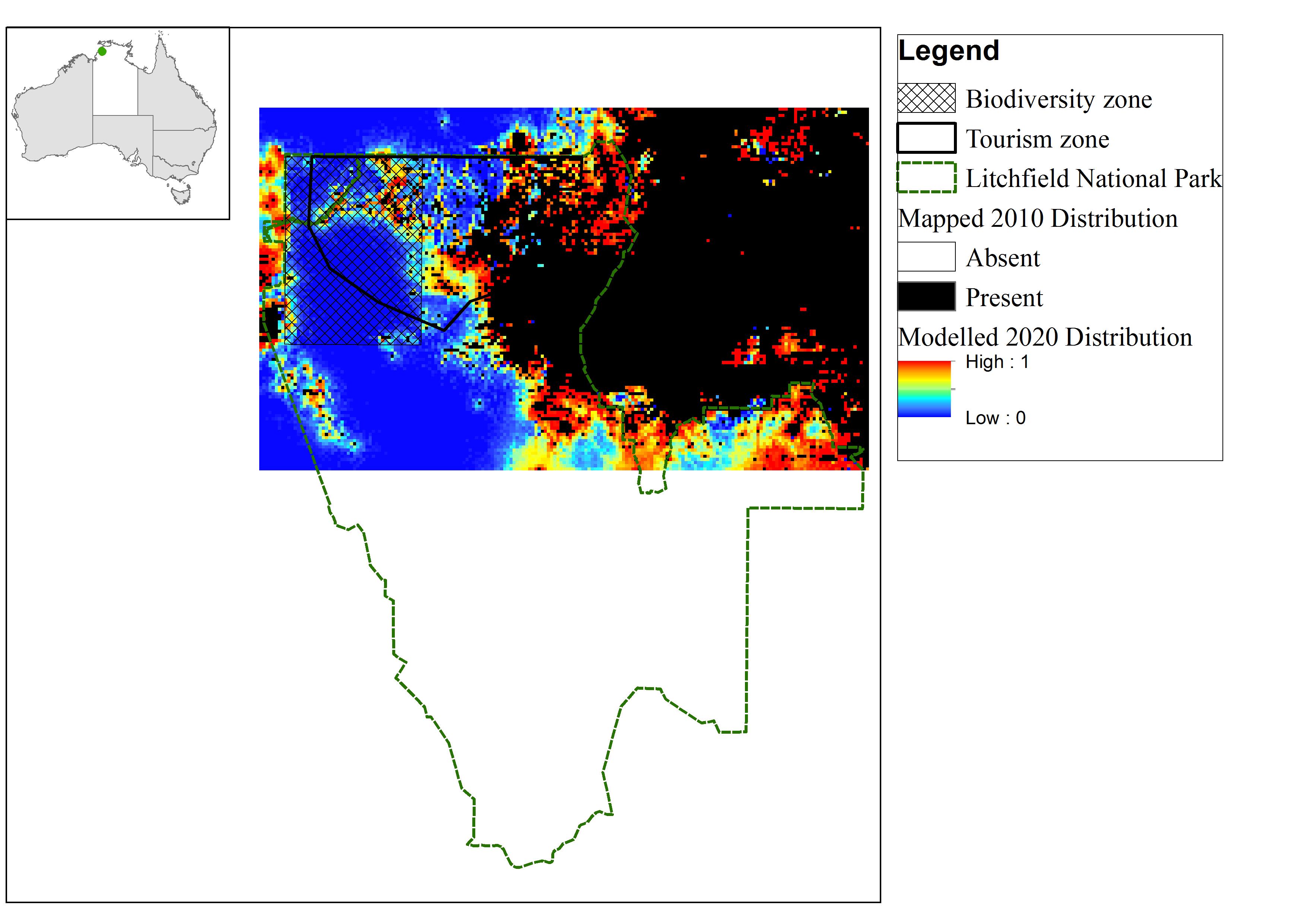
Litchfield National Park is a national park 100km south of Darwin in the Northern Territory, Australia. The park is known for its stunning scenic and cultural features. However, our research has shown that some of the park’s most popular attractions and ecologically important areas are at risk from the impacts of a highly invasive grass.
Gamba grass (Andropogon gayanus Kunth) is an Australian Weed of National Significance (WoNS) and poses a major threat to ecological, economic and social aspects of life in northern Australia. While Australia’s savanna is largely intact, invasive grasses such as gamba grass pose a major threat to its ecological function and biodiversity, particularly through increased fuel loads (meaning that there is a higher risk of fire) and changed fire regimes. Gamba grass poses the greatest threat to Australian savannas, growing up to 4.8m tall and carrying fuel loads up to seven times higher than native grasses. This makes both the native tree canopy and understory more susceptible to fires.

We modelled the spread of gamba grass in and around Litchfield National Park. Our results indicated that if nothing is done to manage the infestation it would likely double in the next ten years. Therefore immediate and strategic action is critical. Our modelling has helped park management to prioritise action to address the threat of gamba grass, including delineating a containment zone around core infestations and pursuing further funding to support the expansion of their management strategy to eradicate infestations in priority areas.
Spread Models are Fundamental, but not Enough
Spread models provide the critical foundation for characterizing the risk of invasive species, but they do not provide the next level of detail needed for action. Managers need to be able to design and test strategies and calculate the level of resourcing that this would require. Demographic spread models can be interfaced with management models to prioritize action and evaluate the effectiveness of management strategies.

For example, we provided further detail to Litchfield National Park on potential management strategies by interfacing Marxan – a widely applied conservation planning tool – with a dynamic biophysical model of gamba grass to optimally allocate funds to eradication and control programs. Although it would be the most costly option in terms of total budget, our analysis suggests that a management plan that involves both containing the core infestation, controlling spread and eradicating infestations in conservation priority areas is the most cost-efficient option (in terms of cost per ha of avoided infestation) and would significantly reduce the current infestation within the park over the next 10 years.
Our analysis allows managers to explore priorities for action under variable budgets and to test the effectiveness of different strategies. Demographic spread models lay the critical foundation for this approach, but further research on models that incorporate both the spread and management of invasive species is needed to support informed management decisions.
To find out more about spatially explicit individual-based spread models, read ‘Distribution, demography and dispersal model of spatial spread of invasive plant populations with limited data’ by Vanessa Adams et al.
This paper is part of our Demography Behind the Population Virtual Issue.
