Post provided by RUBEN REMELGADO
“Man must rise above Earth to the top of the atmosphere and beyond, for only then will he fully understand the world in which he lives” – Socrates (469-399 BC)
 Since the launch of the first Landsat mission in 1972, several new earth observation satellites made their way into Earth’s orbit. As of 2018, UNOOSA recorded an impressive 1980 active satellites. Of those, 661 were dedicated to earth observation. These numbers show how widespread the use of remote sensing technologies has become.
As space agencies recognised the scientific and economic value of satellite data, they made it open access. By doing so, they gave the scientific community the means to develop a growing variety of spatially explicit – and often temporally dynamic – data products on both the land and the atmosphere. Over the years, those of us studying movement ecology have greatly profited from it.
As earth observation technologies improve, so does GPS tracking. Nowadays, the error of state-of-the-art GPS devices in registered in few meters! Combining them with solar power technologies also allows for long-term animal tracking. These factors offer a unique insight into animal behaviour. But we can only make sense of it in combination with satellite data. When doing so, we can determine how an animal reacts to environmental change and refine our understanding of its environmental requirements. The use of remote sensing (as this combination of methods is known) in movement ecology demands improvement though.
Remote Sensing in Movement Ecology: Where We Are
Open-source initiatives such as RStoolbox let non-specialised audiences make expert analyses. Combining remote sensing and animal movement data is not a simple task though. As Neumann discussed in an insightful paper, movement and remote sensing have intrinsic differences in spatial and temporal resolution that make it difficult to use them together. As we pointed out in a related work, the tools and data to overcome those difficulties are within reach. Unfortunately, the scientific community often overlooks these challenges.
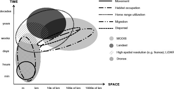
What causes these difficulties? The different ways that movement ecologists and remote sensing experts see the world is a likely culprit. Movement ecologists often spend their time close to the ground. They work directly with animals and see tracking technologies as an extension of their field observations. When they observe the world through remote sensing technologies, it is natural for them to ignore the loss of detail created by a decreasing spatial and temporal resolution. On the other hand, remote sensing experts are used to seeing the world through fuzzy lenses. Consequently, they have a different way to communicate their data and tools, often missing the key audience of users that is the movement ecology community.
Considering these issues, it is safe to say that improving the use of satellite data in movement ecology goes beyond integrating advanced remote sensing methods. It requires a new paradigm on how ecologists see remote sensing and its limitations. As with every scientific development, changing the status-quo depends on common and frequent lines of communication between animal movement and remote sensing experts. But how can we do this?
Remote Sensing in Movement Ecology: Where We Want to be

The challenges of linking animal movement and remote sensing data led us to create rsMove. This R package offers simple tools to combine animal movement and satellite data in a ‘remote sensing friendly’ manner that respects the limitations of satellite data. But the package doesn’t just contain technical tools.
As we show in ‘rsmove—An r package to bridge remote sensing and movement ecology’, rsMove introduces movement ecologists to the mindset of a remote sensing expert. It describes a workflow that helps ecologists test methodologies that depend on remote sensing data, from the selection of study sites to the choice of data products. It also offers standardised reporting on animal-environment interactions that are helpful communication tools.
Movement Ecologists and Remote Sensing Experts: Working Together for a Better Future
Improving the use of remote sensing in movement ecology is a two-way street. As we refine our understanding of animal behaviour, we expand our view on what is possible with satellite data and on what data products are required. In light of the recent IPBES report, which highlighted 1,000,000 threatened species, such information is critically important. Knowing the environmental requirements of a species and understanding its satellite data dependencies can significantly improve global monitoring and keep us one-step ahead of biodiversity decline. In this context, we believe rsMove is a huge asset, offering a line of communication between movement ecologists and remote sensing experts.
To find out more about rsMove, read our Methods in Ecology and Evolution article ‘rsMove—An r package to bridge remote sensing and movement ecology’ (No Subscription Required)
