
Post provided by Jaume A. Badia-Boher

In 1997, a pair of peregrine falcons settled on a cliff in Hungary. It was the first breeding pair in the country since the species disappeared during the pesticide crisis, in the 1960s. Since then, researchers, rangers, and volunteers of MME-BirdLife Hungary’s peregrine conservation group have checked nearly every breeding site, every season, and ringed chicks whenever they could. Today the population holds more than 120 pairs.
Datasets like this exist thanks to people who give years, often decades, of their free time to monitoring. But not all monitoring data are equally easy to collect. Recording whether a territory is occupied takes one or a few visits and a pair of binoculars. Ringing means reaching nests or trapping wary adults, and that is only the beginning: getting a handful of resightings or dead recoveries can take years, if not decades, of effort. In Hungary, they managed to ring 893 peregrines, but only 61 were ever seen again as breeders. Many monitoring programmes look the same: a large territory occupancy dataset and a much smaller mark-recapture dataset.
Small mark-recapture datasets can still be enough to estimate survival, the most critical parameter for population viability, and how it varies with age or yearly. The problem arises when we want to estimate how survival varies spatially. Threats are rarely distributed evenly across a landscape: for the peregrine, power lines are denser around or between urban areas, wind farms cluster where wind conditions are favourable, and predators concentrate in favourable habitat or near prey. Knowing where mortality is highest, and why, is exactly what conservation planning needs to allocate their efforts efficiently. However, estimating spatial variation in survival requires very large mark-recapture datasets over wide areas, which are rarely available.
An intuition and a model
I am Jaume A. Badia-Boher, a postdoctoral researcher in the Population Biology research unit at the Swiss Ornithological Institute. Together with Michael Schaub, Mátyás Prommer, and Marc Kéry, and other members of our group, we are working to make spatial survival estimation more accessible. For the last couple of years, an intuition kept nagging at us: territory occupancy records, when taken over the years, must contain some information about survival and its spatial variation. If a territory is emptied over consecutive years, a possibility is that the territory owner died. If some territories in an area are emptied more often than others, this may be because their holders survive worse. Occupancy records should therefore contain some information about survival and its spatial variation.
The problem is that occupancy alone is too noisy from other ecological processes, and that is probably why nobody has come with a method that estimates survival alone reliably with territory occupancy data. So, we asked: what if we combined both datasets in a single integrated model? The mark-recapture data, limited in size, contribute information about survival and its temporal variation, while the occupancy data, more abundant, add information on how survival varies across space.
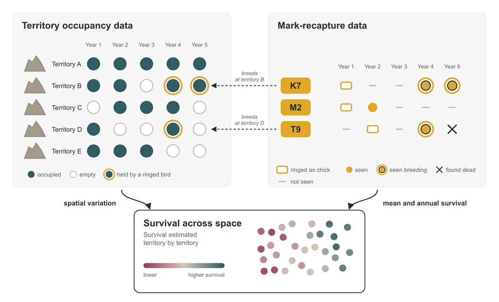
Based on simulations, we found that the integrated model worked surprisingly well. In general, it preserved accuracy of survival estimates and increased their precision substantially. When mark-recapture datasets were too small to estimate spatial variation in survival, occupancy data increased the precision of spatial and even temporal coefficients up to 80%. Precision gains grew as models became more complex and as mark-recapture data became less informative.
Eagle owls, farmland and Hungarian peregrines
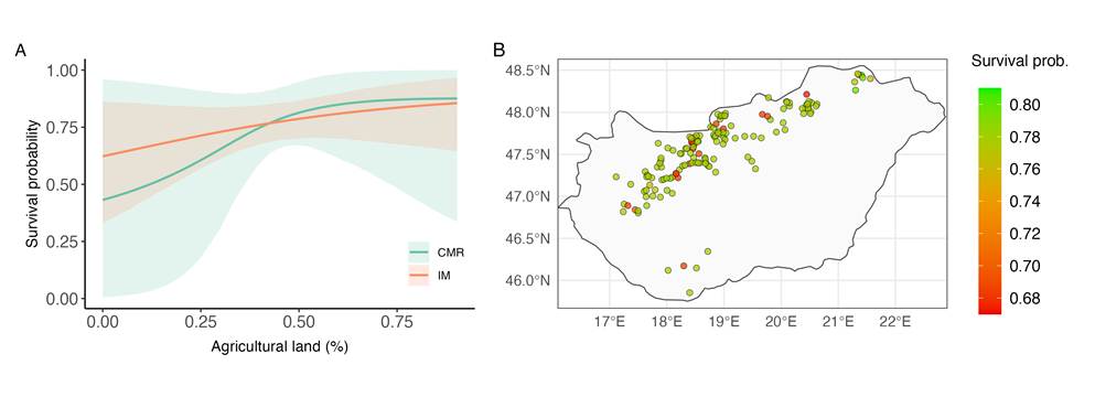
The Hungarian data let us tackle two questions that puzzle peregrine enthusiasts there, but had been out of reach. The first concerns the Eurasian eagle owl, an expanding predator known to predate on peregrine chicks, juveniles, and even adults. Its effects on peregrine breeding success are increasingly documented, but what about adult survival? The second concerns the landscape: does open farmland translate into better survival, as it provides easier hunting and more abundant prey?
With mark-recapture data alone, both effects were too uncertain to interpret. The integrated model narrowed that uncertainty by 42% and 71% respectively, and this let us understand that breeding peregrines tend to survive slightly worse near eagle owls and slightly better in open land. Neither effect is dramatic, but that in itself is useful to know. We could also estimate survival territory by territory and map territories where peregrines survive the worst, which gives a starting point for prioritizing conservation efforts.
Beyond peregrines
The model is not specific to peregrines or even to birds. It is intended for territorial species, like cliff-nesting raptors, nestbox birds, or burrowing mammals and reptiles. So, if you are a researcher, manager or naturalist with a large territory occupancy dataset and a smaller mark-recapture one, this method may be waiting for you. Let’s squeeze the juice out of those long-term monitoring data.
Read the full article here.

